Before we left this morning for Pireus, to meet up with our ship, I took some pitures of the beautiful views from our hotel, the Santa Marina

28. View of sea from Tholos, near Delphi

P1060774.JPG

P1060775.JPG

P1060776.JPG

P1060777.JPG

P1060779.JPG
Tholos, Greece: all of our luggage piled up at the hotel, waiting to be loaded on the bus

P1060780.JPG
Tholos, Greece: father and girl costumed for a festival
We are off to Piraeus to join another group and go on a boat to some of the Greek Islands. We stopped to take a picture of Arachova, and stopped for a picture of Mount Parnassus behind the plain of Thebes.
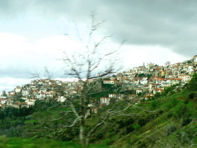
P1060781.JPG
Arachova, Greece

P1060782.JPG
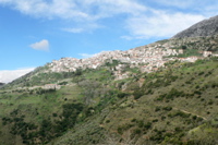
P1060783.JPG

P1060784.JPG

P1060785.JPG

P1060786.JPG

P1060787.JPG
NW of Thebes

P1060788.JPG
NW of Thebes

30. NW of Thebes
Martha Luehrmann and Kerstin Trawick
NW of Thebes: view of Mt. Parnassus. The plain of Thebes is a major cotton-producing area. It used to be a lake, but was deliberately drained in the early 20th c AD to prevent the spread of malaria. This area was the stronghold of the Bronze-age Myceneans. Thebes was the home of Oedipus.

P1060793.JPG
The plain of Thebes is a major cotton-producing area. It used to be a lake, but was deliberately drained in the early 20th c AD to prevent the spread of malaria. This area was the stronghold of the Bronze-age Myceneans. Thebes was the home of Oedipus. We also stopped by the Monument to Greek Resistance in WW II. We came into Orchomenos, a small village. In the 15th c BC the people of Orchomenos had a sophisticated hydraulic system to raise and lower the lake by siphoning it out to natural deep caverns through a channel that could be plugged with a big rock (navel).
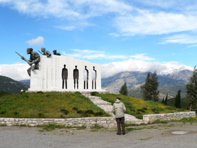
P1060794.JPG
N of Thebes, Greece: Monument to WW II resistance

P1060795.JPG

31. Monument to WW.II Resistance, N. of Thebes

32. At monument to WW II Resistance
Arthur Luehrmann, Kerstin and Leonard Trawick

P1060796.JPG
Arthur Luehrmann, Kerstin Trawick, and Martha Luehrmann

P1060797.JPG
Arthur Luehrmann, Kerstin Trawick, and Martha Luehrmann

P1060798.JPG

P1060799.JPG
N of Thebes, Greece, near the Monument to WW II resistance
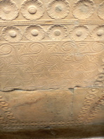
We went to see the Tholos (round) tomb of Minyas, dating from the 13th c BC, and the Ancient Theatre, dating from the 4th c BC. This area was one of the two major centers of the Mycenean world. The tomb was made by first excavating the area, then a beehive shaped tomb with a vaulted roof and a corridor to the central tomb was built from marble rocks. The huge lintel is a single stone. A side area was created, perhaps for actual burial, or perhaps for treasure. The entire tomb is then covered with dirt. To move the rocks to create the tomb, they did not have pulleys, but rather used stone ramps. The Mycenean civilization flourished from about the 16th c BC and declined in the 11th c BC when there was a first great migration to Italy, where they learned a lot about hydraulics from the Etruscans.

P1060800.JPG
Tholos, Greece: Tomb of Minyas and Ancient Theatre

P1060801.JPG
Tomb of Minyas at Orchomenos

33. Tomb at Orchomenos

P1060802.JPG
Tomb of Minyas
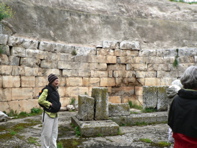
P1060803.JPG
TTomb of Minyas
P1060805.JPG
Tomb of Minyas

P1060806.JPG
Tomb of Minyas

P1060808.JPG
Tholos, Greece: Ancient Theatre
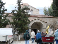
We visited the Monastery of the Koimesis Skripou built in 847 AD using ancient pillars and stones. The circular stones in the exterior walls come from slices of ancient pillars. Under the church (and shown through a glassed-in cut in the floor) is the tiling from a yet older building, and a well for holy water from the older building. Outside there were buildings with cells for the monks, and paintings.

P1060809.JPG
Tholos, Greece: Monastery of the Koimesis Skripou
P1060810.JPG

P1060811.JPG
notice the round stones which comprise much of the walls. They are sliced ancient pedestals from previous temples.

P1060812.JPG
notice the round stones which comprise much of the walls. They are sliced ancient pedestals from previous temples.

P1060813.JPG

P1060814.JPG

P1060815.JPG
cut in the floor, glassed over to see the far far older tiled floor beneath from a previous temple

P1060816.JPG

P1060817.JPG

P1060818.JPG

P1060819.JPG

P1060820.JPG
Monastery of the Koimesis Skripou, Tholos, Greece:

P1060823.JPG

P1060824.JPG
We're on our way south to Piraeus, Greece: We drove on to our lunch stop, where we found out that the bus had sprung a leak in its oil system. Poor Spiro had to load all our luggage onto a sister bus, and we all had to squeeze on the second bus with all its passengers and drive on to Athens and Piraeus.

P1060825.JPG

P1060827.JPG

P1060828.JPG

P1060830.JPG
Piraeus, Greece: port

P1060831.JPG
Piraeus, Greece: mural

P1060832.JPG

P1060833.JPG
orange tree
We embarked on our huge sail (and also power) boat, the Pan Orama, and set off almost immediately for Poros, an island close off the Pelliponese coast. The seas were running quite high, and Martha almost immediately got very seasick. She retired down to her cabin (a BIG mistake) until Arthur chased her up to the deck and Kerstin gave her a Dramamine pill. Even so, Martha skipped dinner and stayed out on deck.

P1060834.JPG
Piraeus, Greece: port

P1060835.JPG

P1060836.JPG

P1060837.JPG

P1060838.JPG

P1060839.JPG

GreekIslandsMap
Map showing the Greek Islands that we visited

P1060840.JPG
P1060842.JPG
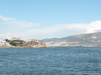
Piraeus, Greece: leaving port

P1060843.JPG

P1060845.JPG

P1060846.JPG

P1060847.JPG
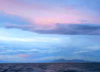
Greece: on the Aegean Sea

P1060848.JPG

P1060849.JPG

P1060851.JPG
Glynn McMillan

34. Underway aboard the Panorama

P1060852.JPG

P1060853.JPG

P1060854.JPG

P1060855.JPG

P1060857.JPG

P1060860.JPG

P1060861.JPG

P1060862.JPG

P1060863.JPG

P1060864.JPG

P1060865.JPG

P1060866.JPG

P1060867.JPG
P1060868.JPG

P1060869.JPG

P1060870.JPG

P1060871.JPG

P1060872.JPG

P1060873.JPG
Entering the straits of Poros one immediately sees the island’s beautiful town on one side and the coast of the Peloponese with the densely green Galata on the other side. It is from that particular strait through which ships pass that the island took its name, since Poros in Greek means “passage”. The island is located 32 nautical miles from Piraeus. It covers an area of 32 square kilometers, and has a population of approximately 4,000 inhabitants. The town of Poros is built amphitheatrically on the two rocky hills of a three-cornered islet called Sphaeria. Its houses, lacking any particular architectural plan, are piled on top of each other with colorful windows and facades, roofed with terracotta tiles. History: Poros in ancient times consisted of two islands: Sphaeria and Kalavria, divided by the sea. Today they are joined by a small cape. Kalavria is very fertile and full of olive trees. In contrast, Sphaeria is arid and rocky, formed by volcanic material. Poros has been inhabited since prehistoric times, but the prosperity of the island came when Ionians founded the sanctuary Poseidon that became the center of the Ionic amphictyonic league during the classical period. Poros followed the historical evolution of Greece and especially that of Athens and neighboring Troezen. Highlights: On the top of the first hill stands the beautiful clock tower, the trademark of the island built in 1910. The other major highlight is Poros’ waterfront, which is the center of life on the island. The famous orator Demosthenes, chased by his enemies, shut himself in the temple of Poseidon in Kalavria where he drank poison in 332 BC. The inhabitants of the island buried him in the courtyard and every year honored him.

P1060874.JPG
Poros, Greece: our ship, the Pan Orama As dinner was ending, we arrived on Poros, an island used by many Athenians for a vacation place. We walked around the port area a bit.

P1060877.JPG
Poros, Greece:

P1060879.JPG

P1060880.JPG

P1060881.JPG

P1060883.JPG

P1060884.JPG

P1060885.JPG
ancient water trough

P1060887.JPG
Poros, Greece:

P1060892.JPG
Poros, Greece:

P1060888.JPG
Poros, Greece: experiments with lights

P1060893.JPG
